South America Daily Snow

By Luke Stone, Forecaster Posted 10 months ago September 4, 2024
Active Stretch Continues
Summary
The first in this series of southerly storms is wrapping up today (Wednesday) and by Thursday morning we'll be on to storm number two. The southerly storm track will bring continued chances for snow through the middle of next week though none of the waves look particularly strong. Later next week, the models push the storm track even farther south which may give us a break in the action.
Short Term Forecast
Solid snow totals in the central zone over the last few days, with Antillancs reporting 30 - 40 cm so far. Farther north, Nevados de Chillan was at 10 cm on Tuesday morning. There will be some lingering snow showers on Wednesday but additional accumulations will be minor.
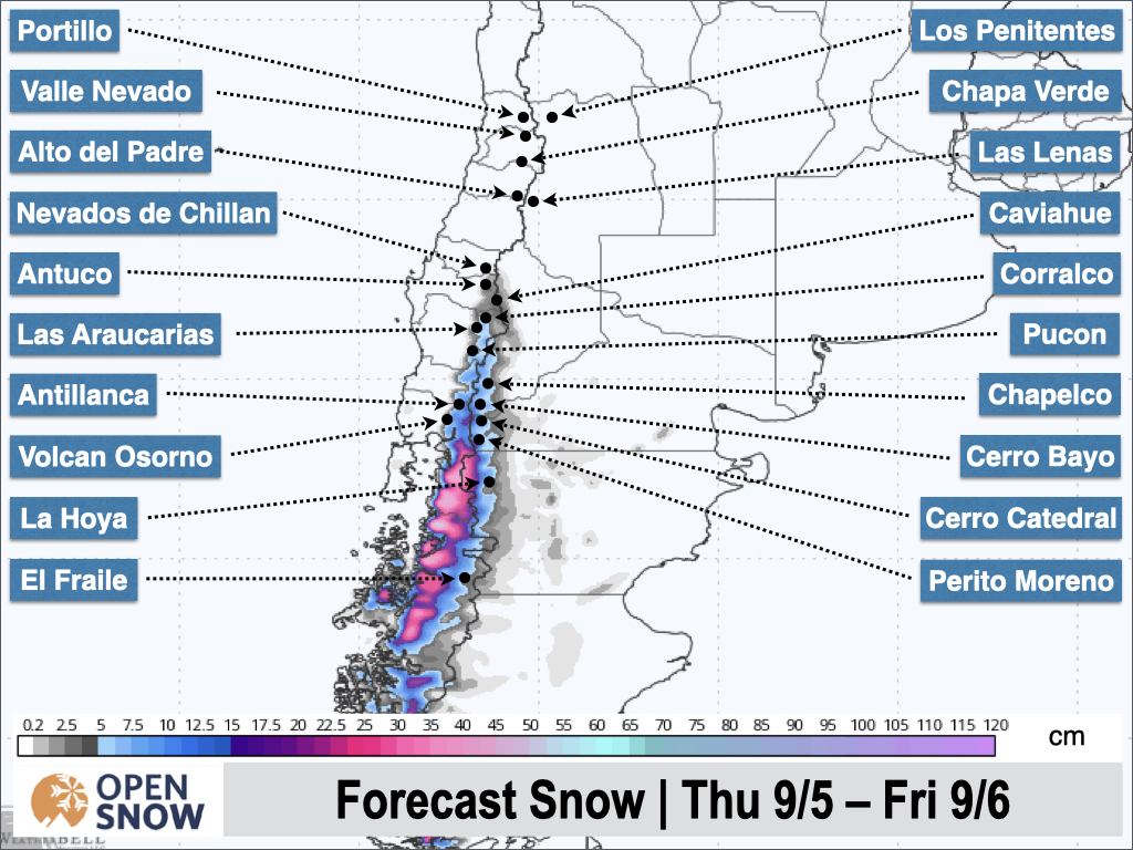
Expect a break in the action on Wednesday evening before the next storm moves in on Thursday morning. The brunt of this storm will occur from Thursday morning through Thursday evening, with light snow after that. Accumulations in the central zone should top out around 15 - 30 cm at Pucon and Las Araucarias, with generally 10 - 20 cm farther south in on the Chilean side. Lesser totals are expected in Argentina. The latest snow forecast from the European model is shown below.
Snow showers should continue through Saturday in the central and southern zones before a short break is expected Saturday night through Sunday night. Most of the moisture remains south of the resorts through Monday morning when the next system tracks a bit farther north. This is looking like another 10 - 20 cm event for the central zone.
Extended Forecast
During the middle or latter part of next week, the storm track pushes farther south once again. This should bring about a break in the action and more spring-like conditions.
Next update on Friday.
Thanks for reading the South America Daily Snow!
Luke Stone (@imlukesnow)
Forecaster, OpenSnow
Announcements

NEW: Global Weather Stations
Get the latest temperature, wind, and snow data from over 50,000 global weather stations with our new “Weather Stations” map overlay.
- Tap the “Maps” tab.
- Tap the overlay button.
- Tap “Weather Stations”.
- Select any chip at the top of the screen.
- Tap any station to view current and historical data.

Make sure you're updated to the latest version of the OpenSnow app (App Store / Google Play > OpenSnow > Update) or visit the OpenSnow website (OpenSnow.com).
View → Weather Station Map
About Our Forecaster


