South America Daily Snow

By Luke Stone, Forecaster Posted 9 hours ago July 23, 2025
Snow Returns Wednesday Night, Starting An Active Pattern
Summary
Active weather returns on Wednesday night and should continue for much of the next week, but it's not an entirely perfect storm cycle with some warmer temperatures threatening high snow levels. Overall, these storms will bring significant accumulation that will benefit the region.
Short Term Forecast
Once again, the models have undergone significant changes over the last two days, particularly in the mid- and long-range. I briefly touched upon the potential for over 1 m of snow during this timeframe, but the forecasts have backed off. The short-range forecast, including the storm beginning on Wednesday night, remains on track.
The first storm is still expected to get started on Wednesday night, as an upper-level low comes on shore with a weak atmospheric river, kicking off snow in the southern Andes. Snow will move into the southern and central zones on Thursday, falling at a light to moderate clip as winds pick up from the northwest. A cold front will also push through the region, dropping snow levels to around 1200 m on Thursday.
Snow will become heavier on Thursday night and Friday, especially in the northern half of the central zone, while winds remain strong. Snow will generally taper to showers on Friday night, except for the Argentinian side of the central zone, where the surface low could keep moderate snow going through Saturday morning. The cold front will have moved through the area by this time, so this snow should be on the fluffier side. Given the lack of snow in this area, we'd actually prefer more dense snow, but we'll take what we can get.
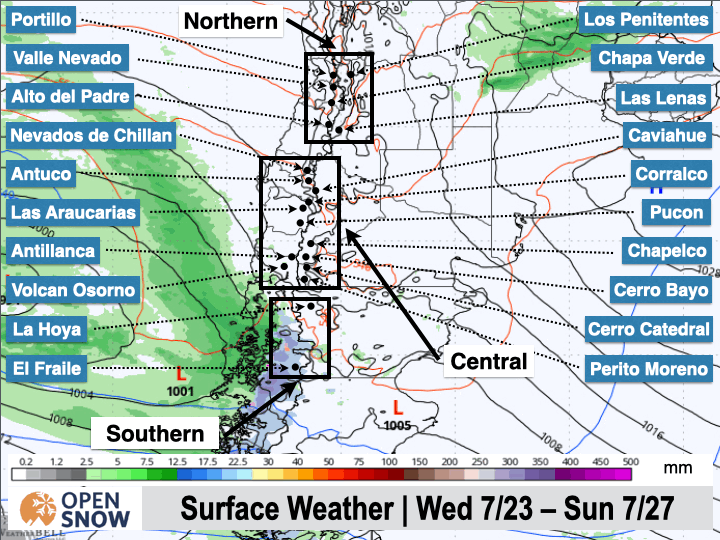
Below, you can see how this storm is expected to unfold starting on Wednesday.
Below is the latest snow forecast from the European model through Saturday.
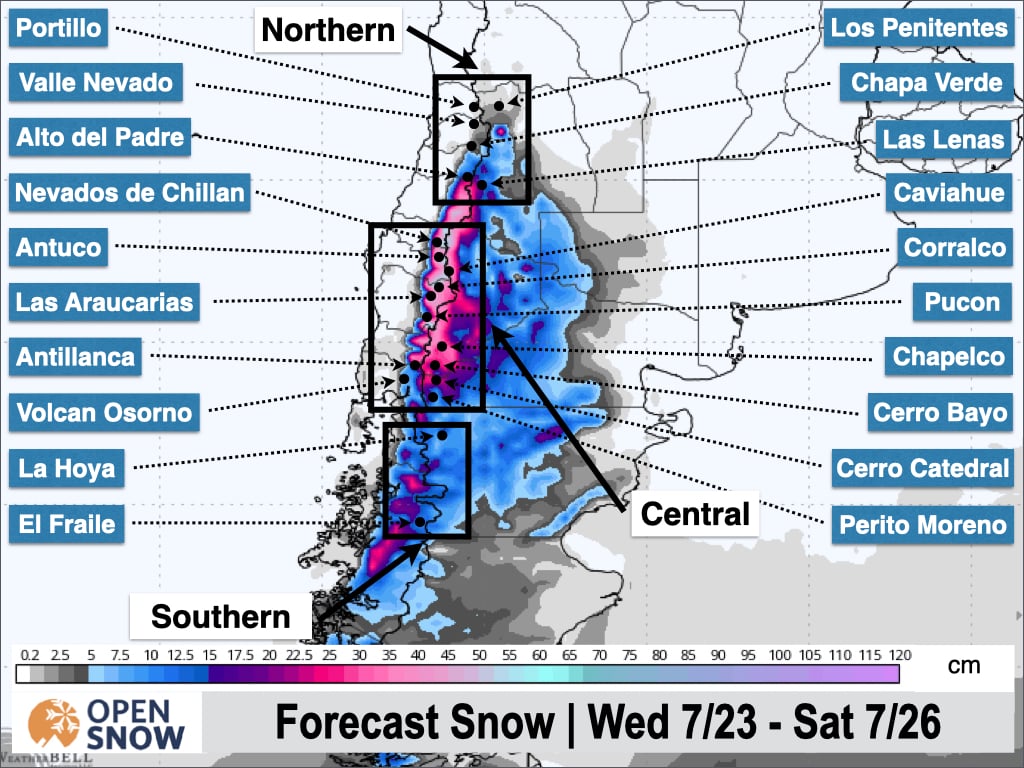
Expect 10 to 20 cm for most of the central zone, with 25 to 50 cm in the northern parts around Nevados de Chillan and Corralco. This storm will mostly miss the northern zone, although Las Lenas could see 5 to 15 cm of snow.
The next storm will move in fast, bringing snow to the central and northern zones as early as Saturday night. This will bring another round of accumulating snow to the central zone while the northern zone gets in on the action, too.
Later in the weekend, though, a third upper-level disturbance will approach the Andes with another atmospheric river, bringing significant moisture, warmer temperatures, and higher snow levels. The latest guidance has snow levels climbing above base elevations with a threat of rain on Monday. I'll get into those details in my next post.
Extended Forecast
After the warm phase of the next storm early next week, the models show another round of snow in the Tuesday to Wednesday timeframe, with colder temperatures, so this is something to watch.
Next post on Friday.
Thanks for reading the South America Daily Snow!
Luke Stone
Forecaster, OpenSnow
Announcements

NEW: Forecast Range Graphs

You can now view individual forecasts from global and regional high-resolution weather models in OpenSnow. This includes forecasts from the GFS, ECMWF, HRRR, and ICON models, as well as the OpenSnow blend.
The graphs give you a behind-the-scenes look at the forecast and make it easier to see if the forecast models are in tight agreement or if there is a wide range of potential outcomes over the next 10 days.
Note: This is currently only available in the OpenSnow iOS app and website (OpenSnow.com). Android will be available soon.
Getting Started
- Go to any location screen.
- Scroll down under "Weather" or "Snow Summary".
- Tap "View Interactive Chart" in the app.
- Adjust the model, timeframe, or data view.

Why is the Forecast Range helpful?
Understand if there is high or low confidence in the forecast. If all models show a similar forecast, there is higher confidence in the forecast, and vice versa.
Dig into the details. If you have experience looking at weather model data and trust certain models or higher-resolution models, you'll be able to isolate your favorite data.
View → Forecast Range Graphs
About Our Forecaster


