South America Daily Snow

By Luke Stone, Forecaster Posted 1 year ago June 21, 2024
It's Still Dumping, and There's No Sign of It Letting Up
Summary
This remarkable stretch of cold and active weather continues on Friday, as heavy snow pounds the northern and central resorts. This storm will continue to bury this region through Sunday as it barrels through the southern part of the continent. A smaller storm will keep snow going in the north later this weekend into early next week before the next storm in this cycle arrives later Tuesday.
Short Term Forecast
Another South America Daily Snow, and another round of snow totals to report. Once again, these are from Thursday, and if I see any updated totals, I will add them here. Portillo is expected to open on June 26th.
These totals were updated at 1:45 in the afternoon. If there are two totals, they represent 24 and 48-hour totals. If only one total is listed, its for the last 24 hours.
- Nevados de Chillan: 65 cm (26in), 120 cm (48 in)
- Cerro Catedral: 30 cm (12 in), 50 cm (20 in)
- Corralco: 15 cm (6 in), 32 cm (13 in)
- Cerro Bayo: 20 cm (8 in) - summit, 20 cm (8 in ) - base
- Las Lenas: 1 m (39 in)
- Portillo: 18 cm (7 in)
- Valle Nevado: 14 cm (5.5 in)
The storm that delivered these totals is a long way from over, with a lot more snow on the way through Sunday. The heaviest snow will again be in the northern zone, at resorts like Portillo, Valle Nevado, Nevados de Chillan, and Las Lenas, with another 40 - 80 cm + possible. In the central zone, resorts like Corralco, Las Araucarias, Pucon, and Antuco will do well, with an additional 30 - 60 cm possible through Sunday. Totals will drop off south and east of Antillanca.
The latest snow forecast through Sunday from the American model is shown below.
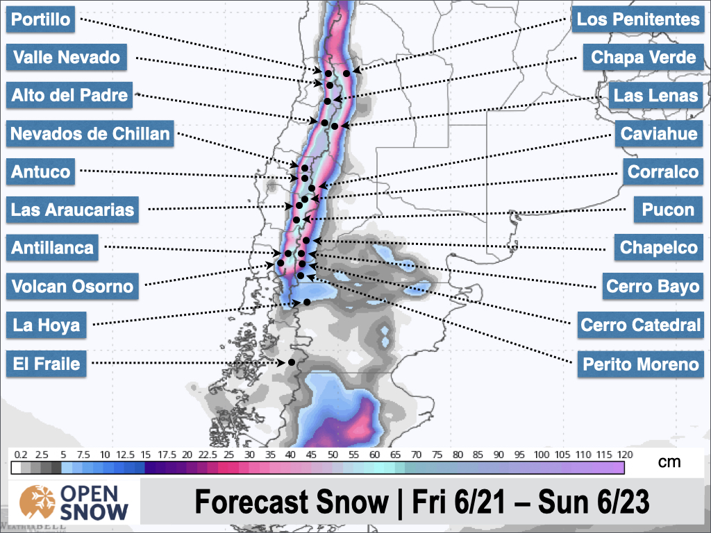
We may see a short break on Sunday in the north before a smaller storm brings snow back on Sunday night. This system will keep snow going through Tuesday morning and may add another 5 - 15 cm, with perhaps a bit more at Portillo. Snow won't be nearly as heavy during this time compared to the current storm.
The next storm will arrive around Tuesday night, with a more southerly track favoring the central and southern zones. Snow levels are still expected to rise considerably from Tuesday night through Wednesday night, before starting to fall Thursday morning as a cold front comes onshore. Snow levels should rise above 1800 m, above the bases of the resort in the central zone, and perhaps in the northern zone as well, though precipitation should be less intense.
Still, significant accumulations are possible, especially after the cold frontal passage. The models begin to diverge a bit after Thursday, with the timing of the following storm a bit unclear. We may see the next system moving in as early as Friday, but some models hold off until Saturday. This looks like another powerful system but I'll hold off on additional details until the models come into better agreement.
Extended Forecast
The long-range models generally keep things active through the end of the month and into early July as well. If the models stay consistent, this could end up as one of the snowiest Junes on record. It's a great time to be in South America and the remaining resorts are on track to open within the next week with some of the deepest snowpack in years.
Next update on Monday.
Thanks for reading the South America Daily Snow!
Luke Stone
Forecaster, OpenSnow
NEW: Global Weather Stations
Get the latest temperature, wind, and snow data from over 50,000 global weather stations with our new “Weather Stations” map overlay.
- Tap the “Maps” tab.
- Tap the overlay button.
- Tap “Weather Stations”.
- Select any chip at the top of the screen.
- Tap any station to view current and historical data.

Make sure you're updated to the latest version of the OpenSnow app (App Store / Google Play > OpenSnow > Update) or visit the OpenSnow website (OpenSnow.com).
View → Weather Station Map
Announcements

NEW: Current Global Radar
Track storms worldwide with our new "Current Global Radar" map overlay.
- Tap the "Maps" tab.
- Tap the overlay button.
- Tap "Current Global Radar".
- Scrub the bottom slider.
The radar data is updated every 10 minutes to help you track ongoing precipitation for the past 2 hours.

Make sure you're updated to the latest version of the OpenSnow app (App Store / Google Play > OpenSnow > Update) or visit the OpenSnow website (OpenSnow.com).
View → Current Global Radar
About Our Forecaster


