South America Daily Snow

By Luke Stone, Forecaster Posted 1 year ago June 19, 2024
One Storm Winding Down, Still Two More On the Way
Summary
Another significant storm is winding down on Wednesday but there's still a lot more action to come. The next storm will bring huge totals from Wednesday night through Sunday. A smaller storm will keep the snow flying in the north early next week before heavy snow returns midweek.
Short Term Forecast
The storm that is wrapping up today delivered another round of impressive snow totals, some of which are listed below. Most of these were reported on Tuesday so I will update them if necessary.
- Las Lenas: 1.2 m (4 ft)
- Corralco: 45 cm (1.5 ft)
- Portillo: 47 cm (1.6 ft)
- Cerro Catedral: 23 cm (9 in)
- Valle Nevado: 17 cm (6.5 in)
- Chapelco: 17 cm (6.5 in)
Nevados de Chillan has announced an early opening day of tomorrow, Thursday, June 20th. On the other hand, Las Lenas has decided to cancel the early opening tomorrow, due to the recent and upcoming snow.
Some shower activity may linger through the afternoon but for the most part, this storm is over and skies have been clearing. The next system is fast approaching though and will bring snow back to the Andes Wednesday night. This storm will push a warm front through the region this evening through tomorrow morning before the next cold front starts to bring snow levels back down. They should remain below base elevations the entire time and some of the coldest air of the season is expected by Saturday.
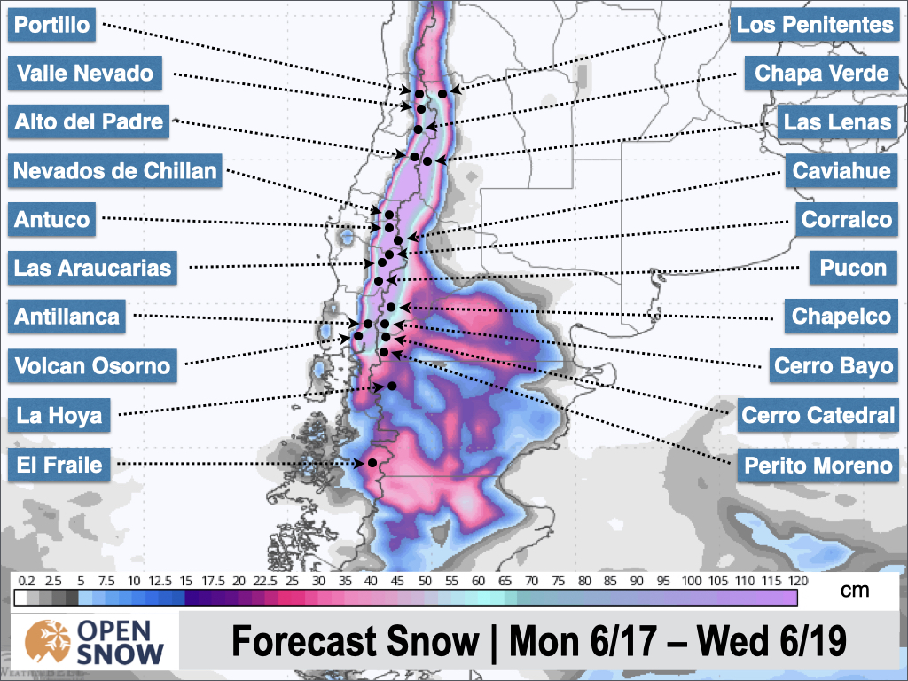
The heaviest snow is expected in the northern part of the central zone, and the southern part of the northern zone, at resorts like Las Lenas, Nevados de Chillan, Corralco, and Antuco. Between .75 - 1.5 m are expected in this area, with up to 2 m possible at Nevados de Chillan.
Farther north towards Portillo and Valle Nevado, expect .5 - 1 m, with amounts decreasing farther south and east in the central zone. The latest snowfall forecast from the American model is shown below.
Extremely heavy snowfall rates will return, especially on Friday. Winds will be strong and further resort/road closures are possible with this long-duration event. The storm should wrap up on Sunday. A small storm is then expected to bring some snow showers with minor accumulations in the northern zone Sunday night through Monday.
After a little bit of a break on Tuesday, the next storm will move in from the south on Wednesday. Right now, this storm looks to favor the central and southern zones. It's a bit too early for totals, but over .5 m is possible in these areas. The latest guidance brings some much warmer temperatures into the region around Thursday, where snow levels could climb above resort bases before a cold front lowers them later in the week. I'll have more details on this storm later.
Extended Forecast
Next week's storm should linger through Saturday. The models show additional storms taking a similar more southerly track to close out the month.
Next update on Friday.
Thanks for reading the South America Daily Snow!
Luke Stone
Forecaster, OpenSnow
Announcements

NEW: Current Global Radar
Track storms worldwide with our new "Current Global Radar" map overlay.
- Tap the "Maps" tab.
- Tap the overlay button.
- Tap "Current Global Radar".
- Scrub the bottom slider.
The radar data is updated every 10 minutes to help you track ongoing precipitation for the past 2 hours.

Make sure you're updated to the latest version of the OpenSnow app (App Store / Google Play > OpenSnow > Update) or visit the OpenSnow website (OpenSnow.com).
View → Current Global Radar
About Our Forecaster


