South America Daily Snow

By Luke Stone, Forecaster Posted 1 year ago June 7, 2024
More Wet But We'll Get White This Weekend
Summary
The last few days have been more wet than white but we’ll change that, at least for some time, in some areas this weekend. We’re in the middle of a very active and wet pattern fueled by atmospheric rivers with more storms and a lot more moisture on the way.
Short Term Forecast
It’s been too warm over the last few days while quite a bit of moisture streamed into the central and southern zones. This likely led to rain at lower and middle elevations much of the time and perhaps at the summits as well. There’s not a lot of reporting on resort websites but the webcams I’ve been watching looked like mostly rain. The northern zone was spared from most of this, fortunately.
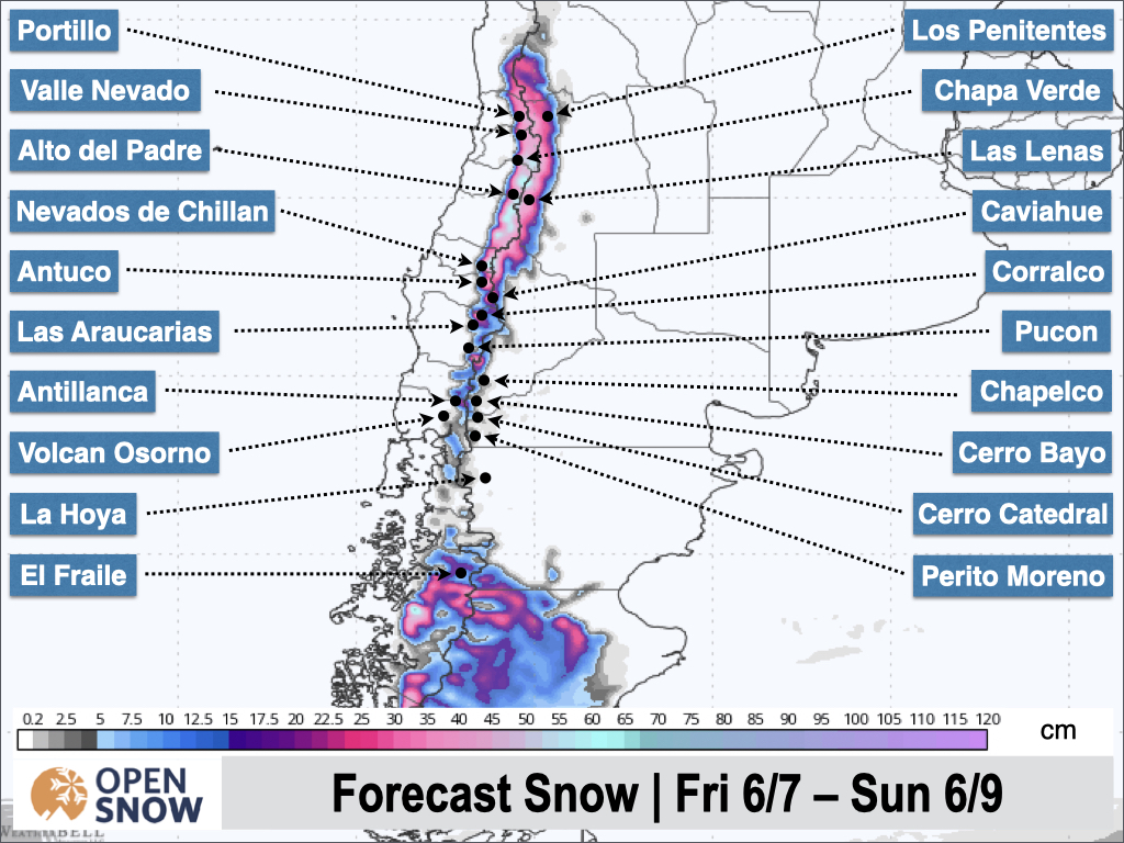
We’ll have somewhat of a break on Friday before the next wave of moisture arrives as the low-pressure system offshore starts to move inland. This will push a cold front through the Andes starting on Saturday morning, though the coldest air won’t arrive until evening.
This will lead to a period of heavy snowfall Saturday night and Sunday, especially in the northern zone. Chilean resorts Nevados de Chillan north through Portillo will see the most snow, with 30 - 60 cm expected. Snow will become lighter Sunday night and we'll have another lull through Monday night. Expect 5 - 15 cm in the central zone during this time.
As the next storm moves into the southeast Atlantic off the Chilean coast, we'll once again see temperatures and snow levels rise. Precipitation won't be as intense from Monday night through Wednesday morning, but the mountains will see more rain at lower and middle elevations during this time.
We'll be in the warm phase again through Wednesday when another cold front will lower snow levels and turn rain back to snow. There will be plenty of moisture left from the atmospheric river early in the week for significant snow with falling temperatures in the latter part of the week.
The models are currently showing some pretty insane snow totals for this period after the cold front moves through. We could see totals well over a meter in the northern zone and over a half meter in the central zone. It's too early to predict detailed snow totals, but there's definitely some potential later next week. Temperatures don't look too cold initially, but there's some indication that a more impressive cold air mass could arrive closer to the end of the week. I'll be keeping a close eye on it.
Extended Forecast
We may finally get a break from this very active stretch around the 15th, with the next chance for snow around the middle of the following week.
Next update on Monday.
Thanks for reading the South America Daily Snow!
Luke Stone
Forecaster, OpenSnow
Announcements

NEW: Current Global Radar
Track storms worldwide with our new "Current Global Radar" map overlay.
- Tap the "Maps" tab.
- Tap the overlay button.
- Tap "Current Global Radar".
- Scrub the bottom slider.
The radar data is updated every 10 minutes to help you track ongoing precipitation for the past 2 hours.

Make sure you're updated to the latest version of the OpenSnow app (App Store / Google Play > OpenSnow > Update) or visit the OpenSnow website (OpenSnow.com).
View → Current Global Radar
About Our Forecaster


