South America Daily Snow

By Luke Stone, Forecaster Posted 1 year ago June 3, 2024
Midweek Storm Trending Warm, More Hope in the Long Range
Summary
A fairly strong storm is on track for the latter part of the week, but the models have been trending warmer over the last few days. This now looks like a mainly rain event, unfortunately. Wet weather continues this weekend, though, as the storm eventually moves inland and brings a cold front into the region. This could be the start of a very long and wet period.
Short Term Forecast
What initially looked like a potentially significant snowstorm, will now bring a heavy dose of rain for most of the region for the middle and latter part of the week. This storm will linger off the coast during this time, before moving inland over the weekend along with a cold front and a transition to snow. The snowpack in the central and southern zones will take a considerable hit before things cool off later in the week.
We may see some showers moving into the central and southern zones as early as Monday night, but the main surge of precipitation begins Tuesday night. A strong low-pressure system will linger off the coast of Chile and deliver copious amounts of moisture.
Moderate to very heavy rain is expected from Tuesday night through Friday, with depressingly large totals during that time. The upper elevations should see some snow, but mid-mountain and lower at most resorts will be rain. Snow levels will be in the 2100 - 2400 m range in the central zone, and over 2400 m in the north.
An atmospheric river will supply the juice for this period, and we may see two more atmospheric rivers during this storm cycle. The GIF below shows these three potential atmospheric rivers moving into the region.
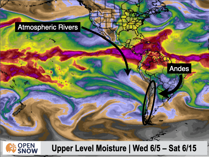
The latter part of this loop is definitely in fantasy land territory, but this period has the potential to bring an incredibly large amount of precipitation.
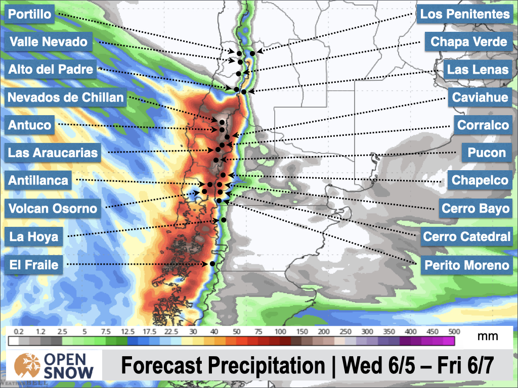
The most significant moisture Tuesday night through Friday will be in the central zone, with slightly less in the southern zone and considerably less in the northern zone. The latest precipitation totals from the American model through Friday are shown below.
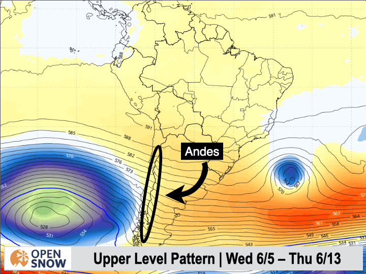
Things start to get interesting Friday night as the upper-level low begins to move inland. It should be accompanied by a cold front that will lower snow levels enough to allow for snow at mid and upper elevations, with significant accumulations possible. As this storm slowly traverses the continent, another upper-level low will move off the coast of Chile right on its tail. This will bring additional rain and snow early next week. Check out the upper-level pattern below from Wednesday through the middle of next week, with a near-constant parade of storms..
A lot of details still need to be worked out for this weekend and beyond, but more wet weather is expected with somewhat cooler temperatures. I don't see any really cold air during this active period at the moment, but there's still time for that to change.
Extended Forecast
The long-range models show this active period continuing through the end of next week at least. It's a bit early for high confidence, but we could see storms continue through the middle of the month.
Thanks for reading the South America Daily Snow!
Next update on Wednesday.
Luke Stone
Forecaster, OpenSnow
Announcements

NEW: Current Global Radar
Track storms worldwide with our new "Current Global Radar" map overlay.
- Tap the "Maps" tab.
- Tap the overlay button.
- Tap "Current Global Radar".
- Scrub the bottom slider.
The radar data is updated every 10 minutes to help you track ongoing precipitation for the past 2 hours.

Make sure you're updated to the latest version of the OpenSnow app (App Store / Google Play > OpenSnow > Update) or visit the OpenSnow website (OpenSnow.com).
View → Current Global Radar
About Our Forecaster


