Western US Daily Snow

By Alan Smith, Meteorologist Posted 5 hours ago August 8, 2025
Quiet Pattern Continues for Most of the West
Summary
The monsoon will remain much weaker than normal with limited rain and thunderstorm potential for most of the West. Southern AZ & NM will see a bit more activity than other areas, but nothing exceptional for this time of year. On Sat-Sun, the Front Range & Eastern Plains of CO will see some strong t-storms. Along the West Coast, temps will heat up briefly before cooler air returns later next week.
Short Term Forecast
Helpful Links:
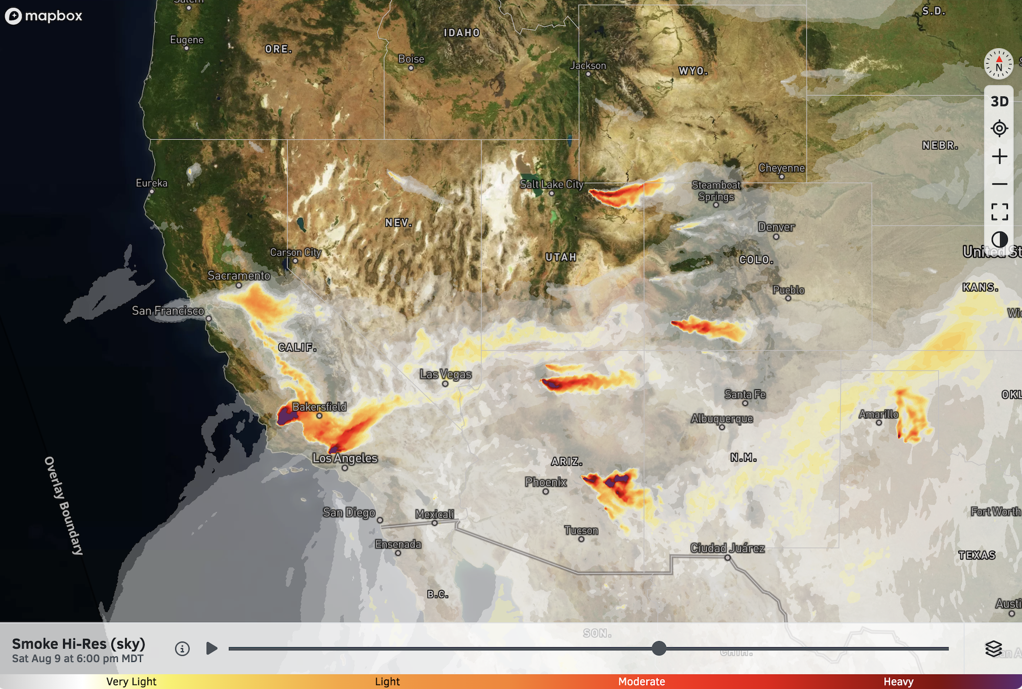
Wildfire and Smoke Update:
Wildfires continue to burn across the Southwest, while the Northwest has seen a reduction in fire behavior in recent days thanks to cooler and wetter weather.
Smoke will continue to impact areas downwind of fires through the weekend, though large-scale smoke and air quality impacts are not as noticeable compared to earlier this week.
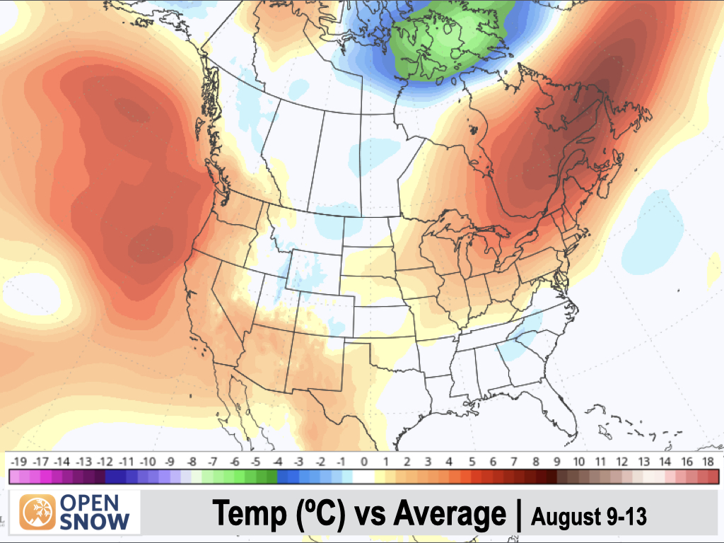
5-Day Temperature Outlook:
The West Coast will see a warm-up this weekend and into early next week with above-normal temperatures expected. The Southwest will also continue to bake with above-average warmth expected. The Central Rockies and adjacent plains will see near-normal temperatures over the next 5 days, with a warming trend early next week following a cooler weekend.
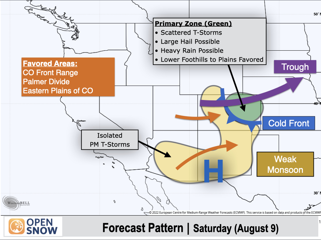
Saturday (Aug 9):
Moisture will increase across Eastern Colorado behind a backdoor cold front, resulting in an uptick in thunderstorms across the eastern slopes of the Front Range and adjacent plains.
Scattered thunderstorms will develop across this region, with the potential for strong to severe thunderstorms over the foothills, I-25 corridor, and eastern plains thanks to increased wind shear (change in wind speed and direction with height) as a result of a trough moving across Northern Colorado.
The strongest storms will be capable of producing heavy rain and large hail of one inch or more in diameter (I-25 corridor included), and a tornado also couldn't be ruled out over the plains east of I-25.
Elsewhere, a weak monsoon will result in isolated thunderstorm chances west of the Divide in Colorado, and across portions of New Mexico and Arizona. Any storms west of the Divide in Colorado will produce light and spotty rain at most, while an isolated heavy downpour couldn't be ruled out in Arizona or New Mexico.
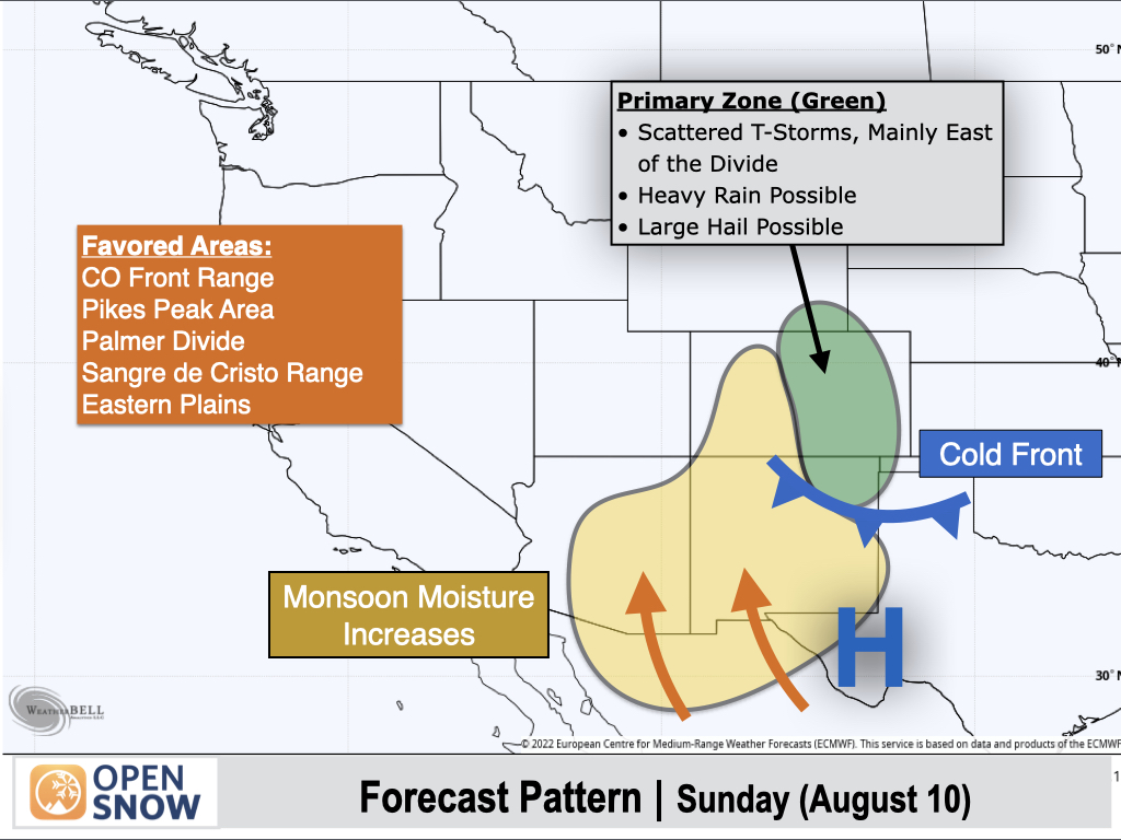
Sunday (Aug 10):
The cold front will slide southward into New Mexico, and easterly winds behind the front will continue to reinforce moisture and thunderstorm chances along the east side of the Divide in Colorado and Northern New Mexico.
Stronger storms will be capable of producing heavy rain and large hail, especially east of the Rockies.
Arizona, New Mexico, and Western Colorado will also see a relative uptick in monsoonal moisture, resulting in a better chance of thunderstorms compared to prior days, although coverage still looks pretty isolated. Storms in Southern Arizona and New Mexico could produce locally heavy downpours.
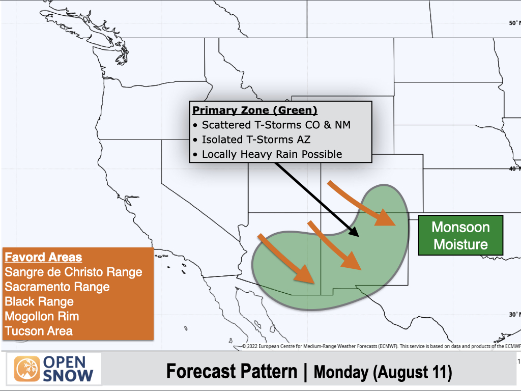
Monday (Aug 11):
Monsoonal moisture will linger over Southern Arizona, New Mexico, and the Sangres in Colorado with winds aloft shifting to northwest (meaning storm motions from northwest to southeast).
Isolated to scattered thunderstorms can be expected across this region, with coverage favoring New Mexico and Southern Colorado more than Arizona. Most storms will produce light to moderate rain, but stronger storms could produce locally heavy downpours.
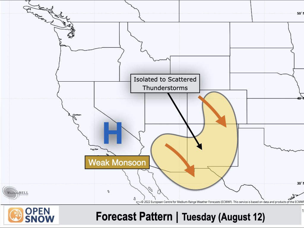
Tuesday (Aug 12):
A weak monsoon pattern will remain in place, though thunderstorm chances may extend a bit further north into Colorado.
Thunderstorm coverage still looks to be isolated to scattered for the most part. Most storms will only produce light rain, but moderate to locally heavy downpours are possible if any stronger storms manage to develop.
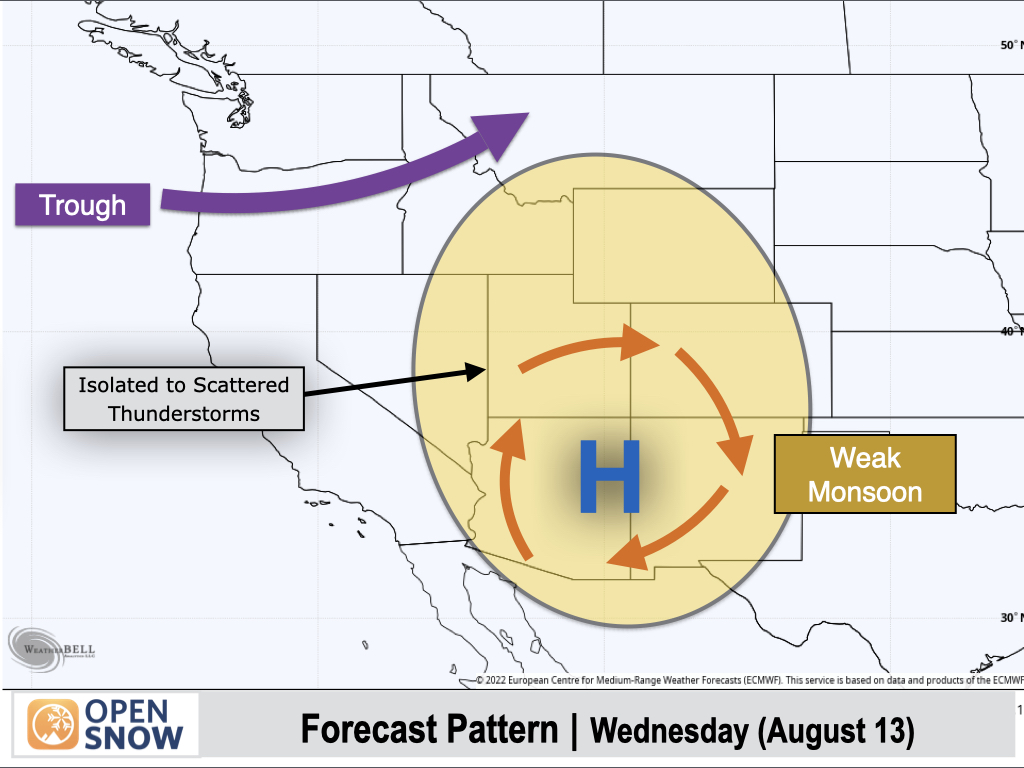
Wednesday (Aug 13):
A trough will move into the Pacific Northwest, and south to southwest winds ahead of the trough will pull monsoonal moisture further north compared to prior days.
This still looks like a fairly weak monsoon push, so while thunderstorm chances are expected further north into the Central Rockies, coverage still looks isolated to scattered at best, with most storms producing light to moderate rain.
Extended Forecast
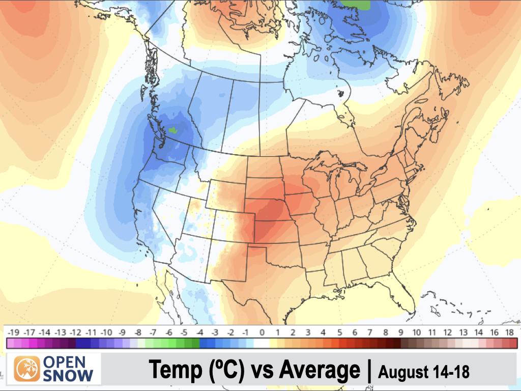
August 14-18:
A big change since my last post is that a trough-dominant pattern is now expected to return to the Northwest, which means a weak and suppressed monsoon further south. Monsoonal moisture looks to favor Southern Arizona and New Mexico, with dry conditions continuing across Utah.
Colorado could see a 1-2 day uptick in storms around August 14-15, then a drier pattern is favored after the 15th.
The Northwest and Northern Rockies will likely see shower and thunderstorm chances return to the picture as these Pacific disturbances move through.
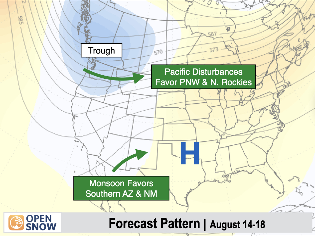
Below-normal temperatures are now expected to return to the West Coast, with cooling extending inland toward the Continental Divide. East of the Divide, temperatures are projected to be warmer than normal.
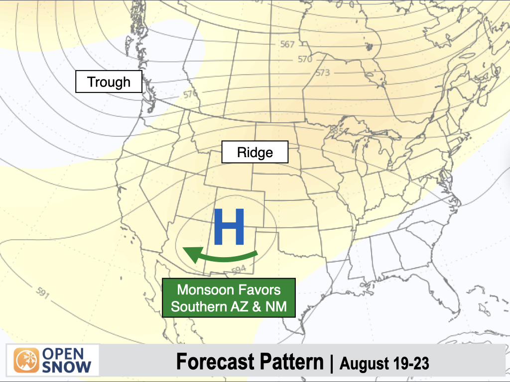
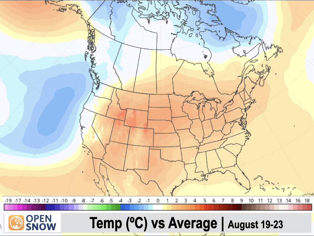
August 19-23:
Longer range models are projecting high pressure to build over the Interior West with weaker troughing possible along the West Coast.
I do think that the monsoon will continue to be weak overall, with moisture favoring Southern Arizona and New Mexico. I don't foresee much relief on the way for Utah, Western Colorado, and Western Wyoming, where it has been very dry this summer.
As for the Northwest and Northern Rockies, long-range models are hinting at drier conditions during this stretch.
However, it should be noted that models have generally not picked up on deeper troughs moving across the Northwest and Northern Rockies recently until we're within 7-10 days, so there is uncertainty in the big picture pattern this far out.
Temperatures are projected to warm up to above-normal levels across most of the Interior West, while remaining near normal if not slightly cooler than normal along the West Coast.
Thanks so much for reading, and have a great weekend! Next update on Monday (August 11).
Alan Smith
About Our Forecaster


