South America Daily Snow

By Luke Stone, Forecaster Posted 1 day ago July 25, 2025
Its (Finally) Dumping in the Andes
Summary
Solid overnight totals in Chile, and it's snowing in Argentina too. This storm is behaving well so far, and it will linger through Saturday morning. After a quick-hitting storm on Sunday, a powerful but warm storm moves in on Sunday night that will bring a rollercoaster of weather through the end of next week. We will see high snow levels, rain, and eventually a transition back to snow.
Short Term Forecast
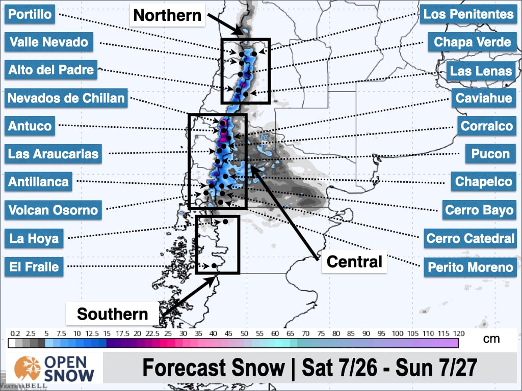
We're finally seeing some fresh snow in the Andes on Friday as a storm moves through the region. Below are some totals as of midday Friday:
- Corralco: 26 cm
- Cerro Bayo: 15 to 25 cm
- Nevados de Chillan: 10 cm
- Cerro Catedral: 4 to 10 cm
As of Friday afternoon, it is still snowing, particularly heavily on the Argentinian side at resorts like Cerro Bayo and Cerro Catedral. Snow will decrease in intensity this evening and taper off by Saturday morning.
Saturday will be mostly quiet before the next storm approaches on Saturday night. This will be a fast-moving storm that will primarily impact the central and northern zones through Sunday. However, another storm will be fast approaching on Sunday night, and there won't be any break in the action for some areas.
Temperatures remain cold enough for the first weekend storm, which will bring a decent shot of snow. The second storm is a different story, and it looks ugly for many areas at the moment. It will feature a strong atmospheric river, high winds, and very warm temperatures, with snow levels rising well above base elevations and potentially even above the summits. Significant rain is expected in the central zone during this time, though the northern zone should be mostly spared. Finally, a return to snow is expected later next week, in the Wednesday to Friday timeframe, with the potential for significant accumulations.
Let's get more into the details.
So we'll have a quick storm impacting the region from Saturday night through Sunday while temperatures remain cold enough. I expect accumulations in the 5 to 20 cm range through the end of Sunday before moisture from the next storm arrives. Below is the latest forecast from the European model.
Temperatures aren't super cold, so the snow will be decent quality. The heaviest snowfall is expected to occur during the day on Sunday.
A strong upper-level low well off the coast will direct an atmospheric river toward the Andes beginning on Sunday night, which will sustain the precipitation even after the prior storm has departed. Take a look at the atmospheric river in the precipitable water forecast below.
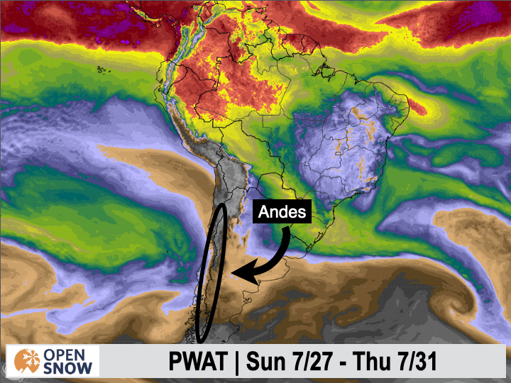
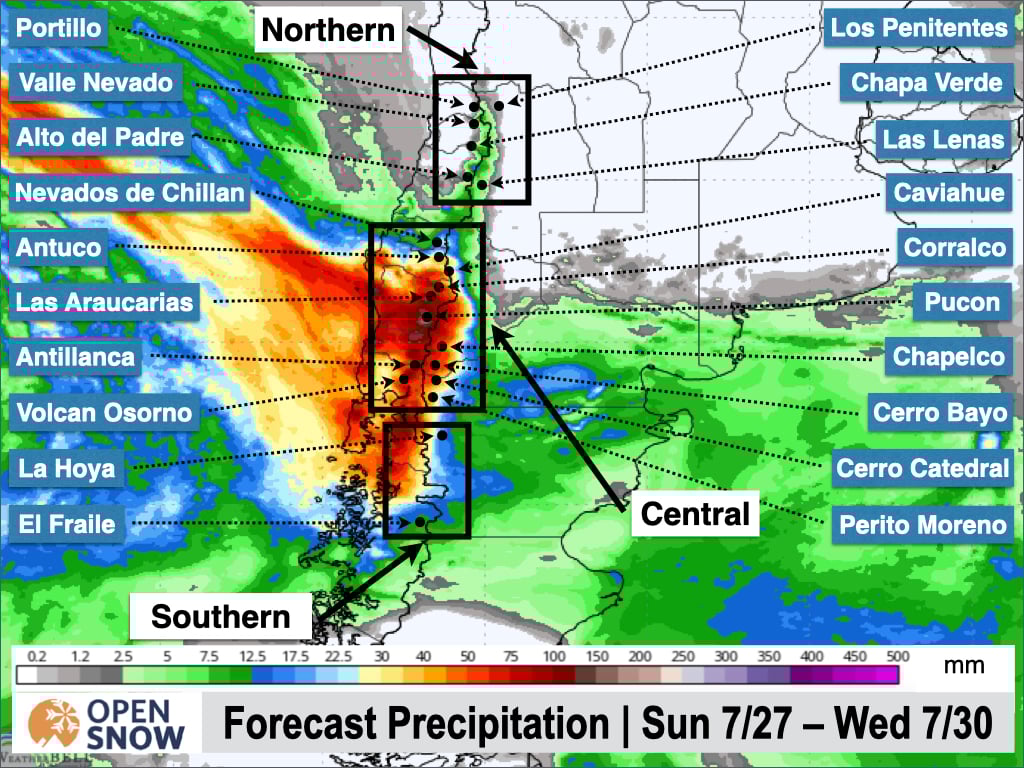
Snow levels will start to rise on Sunday night as the atmospheric river makes landfall, climbing as high as 2200 m in the southern zone and 2900 m in the central zone. As a result, precipitation will mainly be rain from Monday through Wednesday morning. The latest guidance suggests a lot of rain during this time, as you can see below. You can also see the signature of the atmospheric river in the precipitation totals over the ocean extending into the Andes, where 50 to 100 mm of rain is possible during this time.
Snow levels remain high, and the atmospheric river lingers over the Andes while the upper-level low remains offshore through Wednesday. Eventually, this upper-level low will begin moving into South America and push a cold front across as it does so. This will result in a period of heavy snow later in the week. It's still too early for details, but significant snow is definitely possible in the Wednesday to Friday timeframe. I am keeping my eye on this.
Extended Forecast
Another storm is possible later next week, and the pattern may stay active through the weekend as well, but this is getting into fantasy land.
Next post on Monday.
Thanks for reading the South America Daily Snow!
Luke Stone
Forecaster, OpenSnow
Announcements

NEW: Forecast Range Graphs

You can now view individual forecasts from global and regional high-resolution weather models in OpenSnow. This includes forecasts from the GFS, ECMWF, HRRR, and ICON models, as well as the OpenSnow blend.
The graphs give you a behind-the-scenes look at the forecast and make it easier to see if the forecast models are in tight agreement or if there is a wide range of potential outcomes over the next 10 days.
Note: This is currently only available in the OpenSnow iOS app and website (OpenSnow.com). Android will be available soon.
Getting Started
- Go to any location screen.
- Scroll down under "Weather" or "Snow Summary".
- Tap "View Interactive Chart" in the app.
- Adjust the model, timeframe, or data view.

Why is the Forecast Range helpful?
Understand if there is high or low confidence in the forecast. If all models show a similar forecast, there is higher confidence in the forecast, and vice versa.
Dig into the details. If you have experience looking at weather model data and trust certain models or higher-resolution models, you'll be able to isolate your favorite data.
View → Forecast Range Graphs
About Our Forecaster


