New Zealand Daily Snow

By Mike O'Connor, Meteorologist Posted 11 months ago July 25, 2024
Deep Powder on the Line Next Week
Summary
Gusty northwesterlies will bring a few showers to the Southern Lakes Friday into early Sunday, and then to Canterbury on Sunday. But that's all small talk, as the main topic of conversation is centred around a major storm expected to impact the country next week. There's high uncertainty, and deep powder is at stake, which ski fields are desperate for after a month of dry, settled conditions.
Short Term Forecast

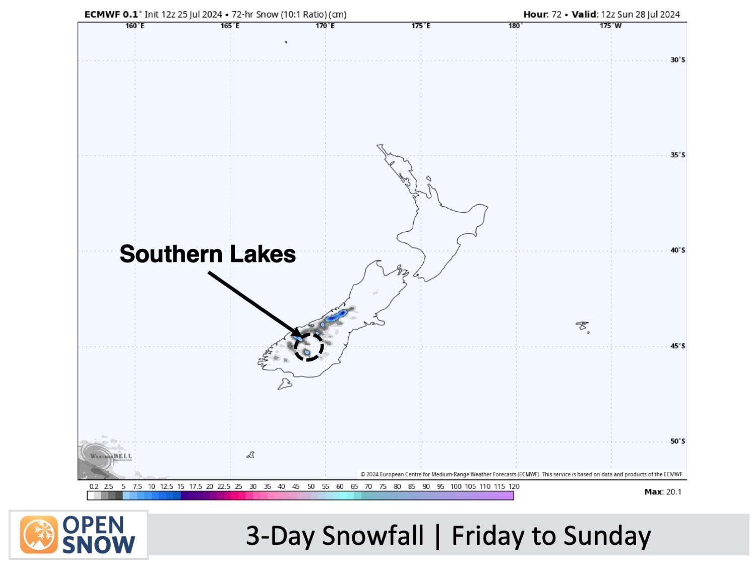
Friday and the Weekend (26th to 28th July)
A gusty northwest flow will dominate the South Island during this period as a front stalls over the bottom of the country. From Friday afternoon onwards, light rain and high-level snow showers will spill over the Main Divide onto the Southern Lakes. They'll mostly hit Treble Cone, although a few will still manage to penetrate far enough eastwards to reach the other ski fields there occasionally.
Snow levels will lower over the Southern Lakes Saturday night as the front starts to move up the country. Snow showers will become more persistent for a time before clearing early Sunday as the winds drop off.
Canterbury, meanwhile, will spend Friday and Saturday with just variable high cloud overhead. However, the front will reach the region early Sunday, with strong, gusty northwest winds carrying light showers of rain and mid- to high-level snow to ski fields here, too, although they'll be more prolific on those closest to the Main Divide.
Extended Forecast
Monday 29th July Onwards
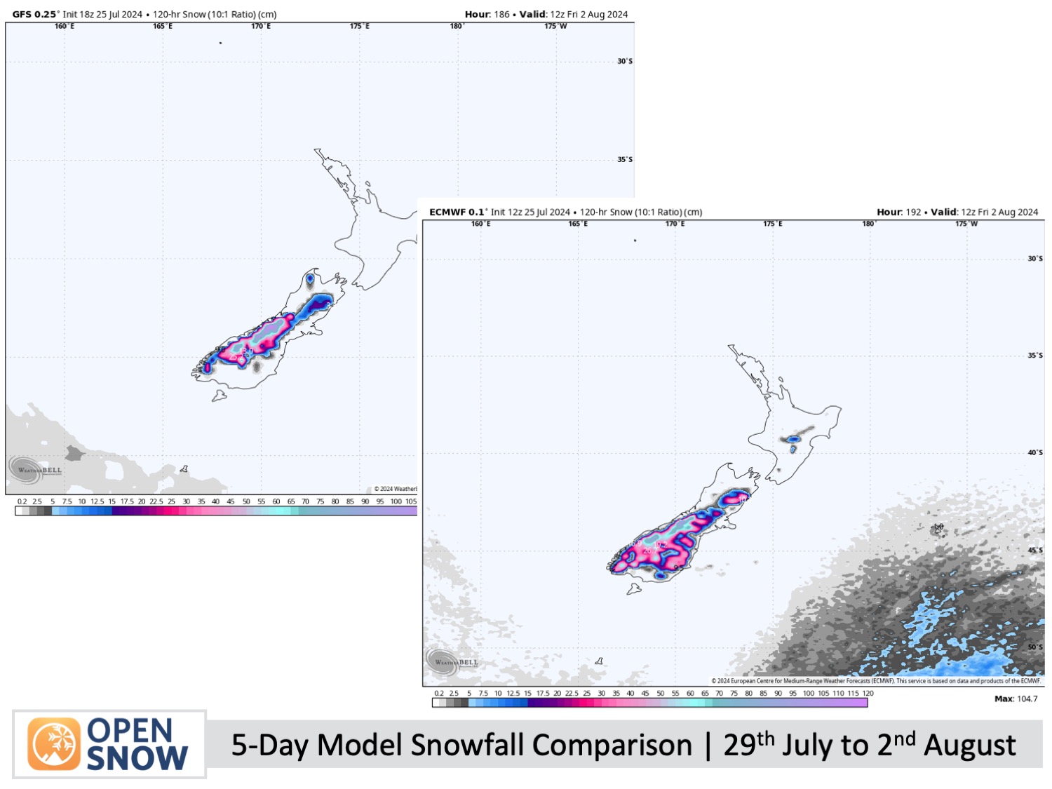
Next week, a major storm will impact New Zealand from Monday, the 29th of July, through to about Thursday, the 1st, or Friday, the 2nd of August. The storm will bring warm, moist air down from the north and cold air up from the south. I've lumped this event into the extended forecast as there is still too much uncertainty to provide a lot of details. The boundary between the warm and cold air will be the difference between rain and snow, and models have been jumping around like mad with this.
As it stands, the Southern Lakes should see heavy snowfall develop on Monday and gradually ease on Wednesday. Snowfall could reach very low levels and cause major disruptions on the roads.
Canterbury will likely initially cop heavy rainfall and high-altitude snow on Monday before the colder air arrives Tuesday, turning it all to snow to low levels before clearing Thursday or Friday.
Earlier forecasts called for a heavy load in Canterbury, but that appears to have shifted southwards to the Mackenzie area (south Canterbury) and to the Southern Lakes. Canterbury itself is more in the light to moderate bracket, but heavy accumulations are still likely up high. Of course, this is all subject to change, and Monday's forecast will shed all the light possible on the storm.
Thanks for reading. I'll continue to provide these forecasts every Monday, Wednesday, and Friday throughout the southern hemisphere season.
Mike O'Connor
About Our Forecaster


